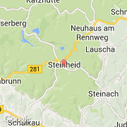
Localidad de Steinheid (Thüringen)
Informations
Cifras
- Código del país :
- DE
- Código postal :
- 98749
- Latitud :
- 50.46447
- Longitud :
- 11.08292
- Huso horario :
- Europe/Berlin
- Universal Time :
- UTC+1
- Horario de verano :
- Y
La localidad de Steinheid pertenece (de mayor a menor) al estado Thüringen y al distrito Sonneberg.
La localidad de Steinheid cubre 23,21 km², tiene 1.183 habitantes y una densidad de 50,97 habitantes por km². La altitud media es de 800 m.
La página web de Steinheid es http://www.steinheid.de
©photo-libre.fr