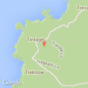
Localidad de Tintagel (England)
Informations
Cifras
- Código del país :
- GB
- Código postal :
- PL34
- Latitud :
- 50.65972
- Longitud :
- -4.74465
- Huso horario :
- Europe/London
- Universal Time :
- UTC
- Horario de verano :
- Y
Informations
Cifras
Ciudades próximas
El transporte en Tintagel
Informations
Cifras
Ciudades próximas
El transporte en Tintagel